Jumat, 23 November 2012

Expedition to the Spice Islands: Corals and Volcanoes

Written by 


Banda Naira, November 2012.  This is the second in a multi-part series chronicling Conservancy scientist Alison Green’s trip with the Coral Triangle Center to conduct a rapid marine assessment in the Banda Sea.
The coral reefs of the Banda Islands have some of the most spectacular and resilient reefs in the world. One of the reasons for this is that they are in the heart of the Coral Triangle, the epicenter of marine diversity.
Another is that there are relatively few threats to the reefs here. There is very little land runoff of sediment or nutrients, fishing pressure is low, and—unlike in other areas of Indonesia (and the world)—these reefs do not appear to have experienced a major coral bleaching event.
But since they are located in the Ring of Fire, they do have to cope with special problemslike earthquakes that shake and break fragile corals and volcanic eruptions that cover reefs in lavathat come with being located in a geologically active area.
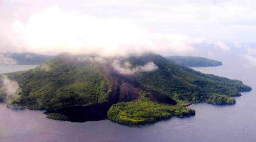
One of the Banda islands, Gunung Api, is an active volcano, which has erupted six times in the last 400 years(most recently in 1988). During the last eruption, some reefs were covered by lava flow (see photo above).
Based on observations of other volcano-affected reefs in places like Hawaii, scientists feared that the reefs would take a long time to recover (50 years or so).
But that was not the case. In 1993, just five years after the eruption, Dr. Tomas Tomascik (a visiting scientist from Canada) found that there was already 60 percent coral cover on the lava flow. This rapid recolonization of a coral community on a lava flow was unprecedented in the scientific literature.
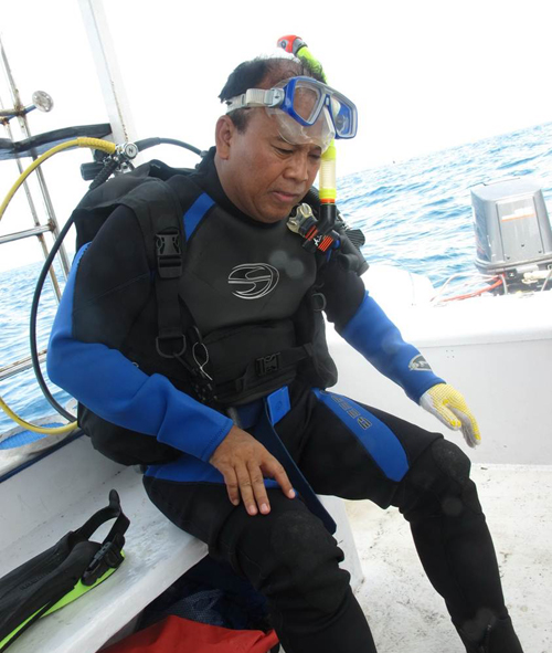
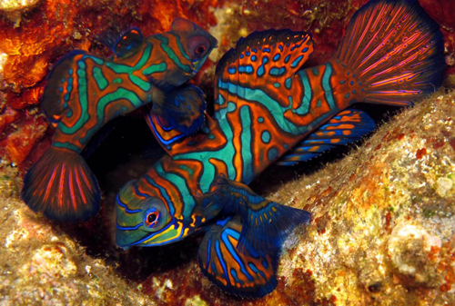
Dr. Suharsono, the leading coral expert in Indonesia from the National Institute of Science, participated in our survey with us in Banda. Dr. Suharsono also visited the area in 1993 and recorded 70 percent coral cover on the lava flow, noting that some of the coral colonies were already a meter across. In 2002, he revisited the area and found that there was 87 percent coral cover on the lava flow, and some of the coral colonies were already three to four meters across!
Ten years later, and 24 years after the eruption, our survey team revisited the area, and Dr Suharsono confirmed that there is still high coral cover and diversity has increased on the lava flow.
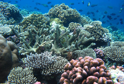
This demonstrates that reefs in this area have such high resilience that they can re-establish coral communities in less than 10 years.
Why is that? It might be because the reefs show many of the characteristics of resilient coral communitiesconsolidated substrate to settle on, good water quality, high coral recruitment and healthy fish populations. The lava flow is also in a sheltered bay where the corals are protected from wave action.
Or is there something else going on? Dr. Suharsono says that it is possible that the chemical composition of the lava has contributed to this rapid recovery. This is something that needs further investigation, and the Banda Islands provide a wonderful natural laboratory for testing this hypothesis.
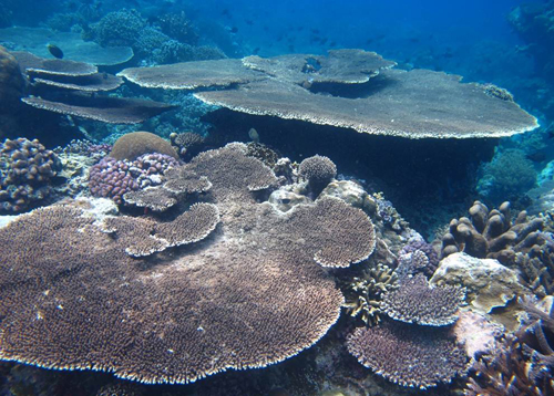
(Image 1: Aerial photo of the active volcano Gunung Api, showing the lava flow that entered the sea and covered the reef with lava in 1988. Image 1 credit: Marthen Welly. Image 2: Dr. Suharsono on the marine rapid assessment in Banda this week. Image 2 credit: Marthen Welly. Image 3: High coral cover and diversity on the lava flow in 2012. Image 3 credit: Marthen Welly. Image 4: Large coral colonies on the lava flow in 2012. Image 4 credit: Marthen Welly.)
Source : http://blog.nature.org/2012/11/expedition-to-the-spice islands-corals-and-volcanoes/


Expedition to the Spice Islands: A Rapid Marine Assessment

Written by 

Banda Naira, November 2012.  This is the first in a multi-part series chronicling Conservancy scientist Alison Green’s trip with the Coral Triangle Center to conduct a rapid marine assessment in the Banda Sea.

Last week I traveled to the Banda Islands, a remote oceanic archipelago in the Banda Sea in the heart of the Coral Triangle. This 40km-long stretch of small volcanic islands rises out of very deep water that extends four to six kilometers beneath the surface.
This archipelago was once known as the Spice Islands, since it was the only source of nutmeg and mace for Europeans until the mid-19th century. These days the islands are becoming a popular destination for scuba divers.
In 2002, a rapid ecological survey led by The Nature Conservancy found that the Banda Islands are an area of high conservation value because of their spectacular landscape, rich history, high biodiversity, unique geography and geology, and excellent marine habitat conditions. While some of the reef fish stocks showed signs of exploitation, the survey reported that the low human population density and fisheries focus on pelagic tuna provide an excellent opportunity forcoral reef conservation.
In 2009, the Banda Sea (including the Banda Islands) was identified as one of the highest marine conservation  priorities in Indonesia based on its high diversity of habitats and coral reef species, strategic role in connectivity (based on current patterns), significant role in sea turtle life cycles, and significance to highly endangered oceanic cetaceans (including blue whales).
Since the Banda Sea is a very deep basin, it has also provided an important refuge for coral reef species during past periods of low sea level, and it may play a similar role in future if (as predicted) sea temperatures increase less here  than in other areas. Consequently, the Banda Sea is considered one of most important areas for expanding the coverage of resilient networks of Marine Protected Areas (MPAs) in Indonesia.
At present, there is only one small MPA in the area, located between the islands of Banda Besar, Gunang Api and Neira (see map above. Local communities and other stakeholders are interested in building on this MPA to develop an expanded MPA network that will provide benefits to both people and nature by ensuring the sustainability of local industries (fisheries and tourism), protecting biodiversity and allowing for adaptation to climate change.
01_map
Last week, I traveled to the Banda Islands to help the Coral Triangle Center conduct a second rapid marine assessment, which focused on collecting the social and ecological information required to design a resilient network of MPAs for the area.
The survey team was comprised of a multidisciplinary group of predominately Indonesian scientists, government officials and local stakeholders. Stay tuned over the next few days as we share the results of our survey—and the implications for MPA network design—with you.

Learn more about the Conservancy’s involvement in the game-changing  Coral Triangle Initiative on Coral Reefs, Fisheries and Food Security..
(Image 1: Mandarin Fish, Banda Islands. Image credit: Marthen Welly. Image 2: Map of Banda Islands. Image credit: Pt. Vifa Mandiri Pratama.)
Source : http://blog.nature.org/2012/11/expedition-to-the-spice-islands-a-rapid-marine-assessment/01_map/

Kajian Cepat Kelautan Kepulauan Banda


Dr. Alison Green at Banda Islands, photo Marthen Welly/CTC


Banda Naira - November 2012, Berbagai upaya menjaga dan melestarikan keanekaragaman hayati kelautan Indonesia terus dilakukan oleh berbagai pihak, untuk mencegah kerusakan dan terus berkurangnya kekayaan alami Indonesia di masa mendatang. Terutama, di perairan di kawasan timur Indonesia, yang hingga kini masih rentan terhadap berbagai ancaman. Namun, sayang banyak wilayah perairan di Indonesia masih belum sepenuhnya terlindungi, dan bahkan belum diketahui potensi kekayaan yang ada di dalamnya sepenuhnya. Misalnya di perairan Banda Neira.
Perairan yang terletak di Maluku ini, berdasarkan survey keragaman hayati yang dilakukan The Nature Conservancy tahun 2002 silam, memiliki setidaknya 310 jenis karang dan 500 jenis ikan. Survey yang dilakukan satu dasarwarsa silam ini, kini dirasa perlu diperbarui untuk melakukan proses konservasi dan pengelolaan perairan Banda Neira ke depan. Hal ini mengingat sampai kini belum ada rencana final pengelolaan jangka panjang  dan zonasi Taman Wisata Perairan Banda Neira seluas 2500 hektar.
 Selain itu, fungsi penting Banda Neira juga terkenal sebagai daerah migrasi tuna sirip kuning dan paus biru.
Terkait hal ini, tanggal 6 hingga 16 November 2012 silam, Coral Triangle Center mengkordinir sebuah Kajian Cepat Kelautan (Marine Rapid Assesment) dengan melibatkan para mitra seperti BKKPN Kupang SATKER TWP Laut Banda, Direktorat Kawasan Konservasi dan Jenis Ikan (KKJI)-KP3K Kementerian Kelautan dan Perikanan, PemKab Maluku Tengah, Camat Banda Naira, TNC,  P2O LIPI, LIPI Ambon, Universitas Patimura, Yayasan Warisan Budaya Banda Naira, Marine Conservation Southeast Asia (MC-SEA), STP Hatta-Syahrir, TNI-AL dan Kepolisian.
Kajian Cepat kelautan ini merupakan salah satu upaya membangun database yang lengkap terkait keragaman hayati dan sosial ekonomi di Kepulauan Banda. Menurut Koordinator Satuan Kerja Taman Wisata Perairan Laut Banda, Julham Pelupessy, kajian ini juga akan digunakan sebagai masukan bagi rencana pengelolaan jangka panjang dan zonasi wilayah ini yang masih dalam penyusunan dokumen final.
Sementara itu, Direktur eksekutif CTC Rili Djohani mengatakan bahwa Kajian Cepat Kelautan ini difokuskan pada pengumpulan data biofisik seperti terumbu karang dan jenis ikan,  dan data sosial ekonomi di Kepulauan Banda seperti perikanan, pariwisata bahari dan kearifan tradisional seperti sasi.
Berdasar Kajian Cepat Kelautan 2012 ini ditemukan kelimpahan ikan Napoleon Wrasse(Chelinus undulatus)yang tinggi hampir di semua pulau di Kepulauan Banda.  Marthen Welly – Koordinator Kajian Cepat Kelautan dari CTC menjelaskan bahwa dari Kajian Cepat Kelautan yang dilakukan mulai tanggal 6-16 November 2012 ini,  dilakukan di 21 titik pengamatan biofisik dan 17 desa untuk survei sosial ekonomi dengan jumlah tim yang terlibat sebanyak 25 orang. Dalam Kajian Cepat Kelautan 2012 berhasil disurvei seluruh pulau yang ada di Kepulauan Banda termasuk Atol Hatta.
Coral Triangle Center (CTC) adalah sebuah NGO berbadan hukum Indonesia dengan lingkup kerja di kawasan segitiga karang dunia (coral triangle) yang meliputi enam negara yaitu Indonesia, Filipina, Malaysia, Timor Leste, Papua New Guinea dan Solomon Island.

Sumber :http://www.mongabay.co.id/2012/11/17/mempertahankan-keindahan-surga-hayati-dunia-di-banda-neira/#ixzz2DAVz8vHb

Survey Mantatow di Kepulauan Banda Naira

Tim survey melakukan Mantatow di Banda, photo Marthen/CTC

Banda Naira - Augustus 2012 - Kepulauan Banda yang terletak di tengah-tengah laut Banda memiliki keanekaragaman hayati laut yang tinggi.  Kecamatan yang berada dibawah administrasi Kabupaten Maluku Tengah, Propinsi Maluku ini memiliki 11 pulau yang memiliki terumbu karang yang indah.  Di kepulauan Banda juga telah dicadangkan kawasan konservasi perairan nasional oleh Kementerian Kelautan dan Perikanan seluas 2500 hektar.
Guna membangun data dasar terkait terumbu karang di kepulauan Banda, Coral Triangle Center (CTC) bekerjasama dengan tim konservasi laut banda melakukan survei distribusi terumbu karang di seluruh kepulauan Banda pada tanggal 29 Augustus – 7 September 2012.  Tim yang terlibat dalam survei ini seperti SATKER KKPN Laut Banda, MC-SEA, Pengawas SDKP Pos Banda Kementerian Kelautan dan Perikanan, Sekolah Tinggi Perikanan Hatta-Syahrir, dan beberapa volunteer.
Metode mantatow ini dilakukan untuk mengetahui distribusi dan kondisi terumbu karang di wilayah yang cukup luas. Tehnik yang digunakan adalah dengan menggunakan papan khusus yang diikatkan ke kapal dengan tali sepanjang 18 meter, lalu ditarik dengan kecepatan kapal sekitar 2 knot.  Seorang pemantau dengan peralatan snorkeling berpegangan pada papan melakukan pengamatan dan menuliskan di dalam lembar survei tahan air setiap dua menit.  Selain terumbu karang, ikan atau biota laut penting lainnya yang dilihat juga dicatat.
Dari hasil survei yang dilakukan selama 37 jam -dengan kondisi surveyor berada di permukaan air- berhasil menyelesaikan 10 pulau dari 11 pulau yang ada.  Pulau Manukang yang terletak cukup jauh tidak dapat diambil datanya karena cuaca.  Pulau-pulau yang berhasil diselesaikan adalah Naira, Banda Besar, Gunung Api, Karaka, Pisang (Syahrir), Batu Kapal, Ai, Run, Nailaka dan Hatta.
Selama pemantauan oleh 2 orang staff  CTC, juga banyak dijumpai berbagai ikan dan biota penting laut lainnya seperti napoleon, penyu, hiu, kerapu, kakap, teripang dan ikan kaka tua.  Kondisi terumbu karang di kepulauan Banda tergolong baik, namun dibeberapa titik terdapat kerusakan akibat bom, jangkar dan pencemaran oleh sampah.
Marthen Welly dari CTC mengatakan bahwa “hasil dari survei ini akan menjadi data dasar terumbu karang yang cukup penting, khususnya bagi upaya pelestarian keanekaragaman hayati laut kepulauan Banda Naira melalui pengelolaan kawasan konservasi perairan yang efektif”.  “Hasil manta tow ini akan ditindaklanjuti dengan kajian cepat kelautan kerjasama CTC dengan Kementerian Kelautan dan Perikakan, LIPI, MC-SEA dan berbagai pihak pada bulan November 2012 yang akan datang” lebih lanjut Welly menjelaskan.
Banda Neira yang resmi ditetapkan sebagai Cagar Alam Taman Laut Banda sejak 1977. Terumbu karang di kepulauan Banda ini merupakan salah satu yang terkaya akan jenis karangnya di antara terumbu karang lainnya yang ada di dunia. Dari 700 jenis karang yang ada di dunia sekitar 432 jenis karang (64%) terdapat di kepulauan Banda.

Sumber :http://www.mongabay.co.id/2012/09/09/pantau-banda-neira-demi-jaga-kekayaan-segitiga-terumbu-karang-dunia/#ixzz2DARne0Gi

Jumat, 11 Mei 2012

Kawasan Konservasi Perairan LAUT BANDA


Kecamatan Banda Neira dikenal dengan peninggalan sejarah berupa rumah-rumah jaman Belanda sekaligus tempat pembuangan pahlawan nasional Indonesia Hatta dan Syahrir pada masa pendudukan Belanda. Sampai saat ini rumah dimana Hatta dan Syahrir pernah tinggal masik terjaga dengan baik, bahkan masyarakat disana memberikan nama Hatta dan Syahrir untuk nama pulau di kepulauan Banda Neira.

Photo Rumah Gubernur Belanda by CTC/Marthen Welly

Kawasan Konservasi Perairan Laut Banda


Kecamatan Banda Neira terletak di tenggara kota Ambon, masuk Kabupaten Maluku Tengah, Propinsi Maluku. Terdiri dari 11 pulau utama, Kecamatan Banda Neira memiliki 12 desa dengan ibukota Kecamatan di pulau Neira. Dari 11 pulau utama, hanya 7 yang berpenghuni yaitu pulau Neira, Banda Besar, Hatta, Run, Ai, Syahrir (pisang) dan Gunung Api.  Sementara sisanya yaitu pulau Nailaka, Karaka, Manukang dan Batu Kapal tidak berpenghuni.  


Photo : Pulau Gunung Api by CTC/Marthen Welly